Who reviews your plans
In Barbados, residential planning applications are primarily and initially reviewed by the Planning & Development Department Office (PDDO). Depending on site context, other agencies may comment (e.g., Ministry of Transport, Soil Conservation Unit, Drainage Unit, Environmental Health, Coastal Zone Dept, Barbados Water Authority, Fire Service).
What we typically submit
- Completed application forms (online) and ownership details
- Location plan, Site plan, Floor plans, Elevations, and sections if requested
- Plot plan, site photos and covenants as required
- Land Tax and any required declarations if requested.
Zoning basics
Most residential sites fall within zones regulated by the relevant Planning agencies which control building height, coverage, and use. Corner and coastal lots often have extra constraints.
These zones vary by location and are confirmed through the relevant authorities during the planning process.
Typical residential setbacks
- Front: often 19ft – 21 ft from center-line of the road, 32 ft from center-line of nearby highways
- Left & Right Sides: 6ft for residential properties & 10 ft for commercial properties
- Rear: 6ft for residential properties & 10 ft for commercial properties
Note: Actual setbacks depend on location, road classification, and zone. Always verify against current guidance and Plot plan.
How we help
We review your survey, confirm likely setbacks, and develop a compliant layout. See our process & approvals.
Common Pitfalls & How to Avoid Them
Avoid delays and extra costs by addressing these issues early.
Unclear land ownership
No written permission from the landowner
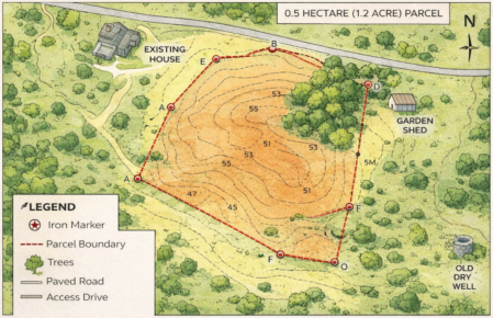
Outdated Surveyor’s Plot
Ignoring site conditions
Site not cleared for inspections
Starting construction too early
Changing plans without approval
Not planning for future phases
Proceeding without professional guidance